Page 37 - PDF_Flip_Book
P. 37
Chapter 12 - Understanding Weather
                                                                                                                12-35

                                                                 tinuous. When in an airplane, temperature is the most
                                                                 easily recognized discontinuity across a front.
                                                                   Pilots flying across a front are likely to notice a sharper
                                                                 temperature change at lower altitudes than higher ones
                                                                 where air tends to become more homogenous. Since rela-
                                                                 tive humidity varies with the moisture content of the air,
                                                                 as well as the temperature of the air, you should also
                                                                 expect changes in dew point with frontal passage. (My
                                                                 grandpa always got upset after cold frontal passage when
                                                                 we left the house door open. He’d yell, “Hey, I’m not pay-
                                                                 ing to heat the neighborhood.” You can probably tell that
                                                                 he desperately needed a course in thermodynamics!)
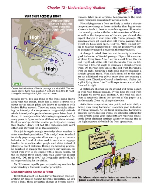
                                                                   A change in wind direction and intensity is another
                                                                 good indication of frontal passage. Figure 60 shows an
                                                                 airplane flying from A to B across a cold front. On the
                                                                 east (right) side of the cold front the wind is from the left,
                                                                 requiring a left crab angle to maintain a straight ground
                                                                 track. On the west (left) side of the cold front the wind is
                                                                 from the right, requiring a right crab angle to maintain a
                                                                 straight ground track. Wind shifts from left to the right
                                                                 are an additional way pilots know they are crossing a
                                                                 frontal area. Direction of travel is irrelevant. Notice that
                                                                 a pilot flying from C to D still experiences a wind shift
            Fig. 60
                                                                 from left to right.
                                                                   A stationary observer on the ground will notice a shift
                                                                 in wind with frontal passage. By the time the cold front
                                                                 in Figure 60 moves past position A, the wind will shift
                                                                 from a southerly (from the bottom of the page) to a
          troughs move. You can think of the front being drawn
                                                                 northwesterly (from top of page) direction.
          along with the trough, much like a horse is drawn to a
          carrot (or as renter pilots are drawn to airplanes with   Aside from temperature, dew point, and wind shift, a
          broken Hobbs meters). There are many variables affect-  falling then rising barometer is another good indication
          ing the intensity of a low pressure trough—high altitude  of frontal passage. As the front approaches, barometric
          winds, intensity of upper-level convergence, latent heat of  pressure lowers. In other words, the altimeter settings for
          the air, to name just a few. Meteorologists go to school for  local airports along your flight path are reporting consis-
          many years to figure out how all these variables interact.  tently lower altimeter settings. Altimeter settings rise as
          So, if you can’t predict the weather perfectly after reading  the high pressure air behind the front approaches.
          this chapter, don’t feel bad (the meteorologists can’t
          either, and they paid for all that schooling).
            Your job is to gain enough knowledge about weather to
          make some basic predictions. This is why I went to school
          to study psychology—to allow me to predict human
          behavior. A friend of mine used to work as a baggage
          handler for an airline when people used stairs instead of
          jetways to board airliners. During the boarding process,
          he delighted in making the passengers very nervous. He
          would walk over to the engine with a broom handle, hit
          the jet engine three times, then walk under the cockpit
          and yell, “OK, try it now.” As I originally predicted, he’s
          no longer working for the airline.
            You’ll become equally good at predicting weather by
          understanding a few basic weather principles.
          Discontinuities Across a Front
            Recall that a front is a boundary or transition zone sep-
          arating air masses having different properties. As you   The infamous aviation weather lecture has always been known to
                                                                  produce a carnival-like atmosphere in the classroom.
          cross a front, these properties change or become discon-

