Page 38 - PDF_Flip_Book
P. 38
Rod Machado’s Private/Commercial Pilot Handbook
     12-36

     Cold Front Characteristics
       A cold air mass overtaking a warm
     air mass is called a cold front. Cold
     air, being heavier than warm air,
     moves along the surface, pushing
     warmer air up in a bulldozer-type
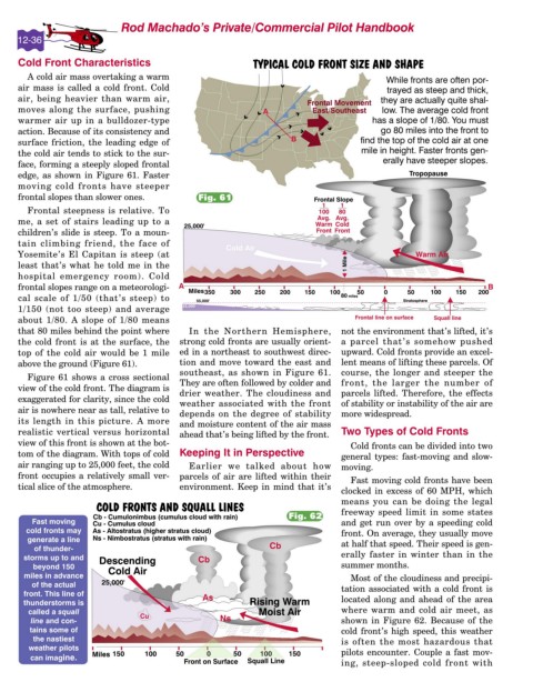
     action. Because of its consistency and
     surface friction, the leading edge of
     the cold air tends to stick to the sur-
     face, forming a steeply sloped frontal
     edge, as shown in Figure 61. Faster
     moving cold fronts have steeper
     frontal slopes than slower ones.         Fig. 61
       Frontal steepness is relative. To
     me, a set of stairs leading up to a
     children’s slide is steep. To a moun-
     tain climbing friend, the face of
     Yosemite’s El Capitan is steep (at
     least that’s what he told me in the
     hospital emergency room). Cold
     frontal slopes range on a meteorologi-
     cal scale of 1/50 (that’s steep) to
     1/150 (not too steep) and average
     about 1/80. A slope of 1/80 means
     that 80 miles behind the point where   In the Northern Hemisphere,  not the environment that’s lifted, it’s
     the cold front is at the surface, the  strong cold fronts are usually orient-  a parcel that’s somehow pushed
     top of the cold air would be 1 mile  ed in a northeast to southwest direc-  upward. Cold fronts provide an excel-
     above the ground (Figure 61).        tion and move toward the east and  lent means of lifting these parcels. Of
                                          southeast, as shown in Figure 61.  course, the longer and steeper the
       Figure 61 shows a cross sectional
                                          They are often followed by colder and  front, the larger the number of
     view of the cold front. The diagram is
                                          drier weather. The cloudiness and  parcels lifted. Therefore, the effects
     exaggerated for clarity, since the cold   weather associated with the front  of stability or instability of the air are
     air is nowhere near as tall, relative to
                                          depends on the degree of stability  more widespread.
     its length in this picture. A more   and moisture content of the air mass
     realistic vertical versus horizontal   ahead that’s being lifted by the front.   Two Types of Cold Fronts
     view of this front is shown at the bot-                                    Cold fronts can be divided into two
     tom of the diagram. With tops of cold  Keeping It in Perspective         general types: fast-moving and slow-
     air ranging up to 25,000 feet, the cold   Earlier we talked about how  moving.
     front occupies a relatively small ver-  parcels of air are lifted within their   Fast moving cold fronts have been
     tical slice of the atmosphere.       environment. Keep in mind that it’s
                                                                              clocked in excess of 60 MPH, which
                                                                              means you can be doing the legal
                                                                              freeway speed limit in some states
                                                                  Fig. 62
                                                                              and get run over by a speeding cold
                                                                              front. On average, they usually move
                                                                              at half that speed. Their speed is gen-
                                                                              erally faster in winter than in the
                                                                              summer months.
                                                                                Most of the cloudiness and precipi-
                                                                              tation associated with a cold front is
                                                                              located along and ahead of the area
                                                                              where warm and cold air meet, as
                                                                              shown in Figure 62. Because of the
                                                                              cold front’s high speed, this weather
                                                                              is often the most hazardous that
                                                                              pilots encounter. Couple a fast mov-
                                                                              ing, steep-sloped cold front with

