
Page 41 - PDF_Flip_Book
P. 41
Chapter 13 - Weather Charts and Briefings: PIREPS, Progs & METARS
13-7
major weather systems around the country, and many
carry a satellite picture that helps provide a look at what
the weather’s doing. Weather-wise pilots study weather
on a daily basis. Simply take the weather chart and/or
satellite photo provided by the paper and examine it
every day. These charts are a lot more accurate than they
were several years ago. You’ll be surprised how weather
savvy you’ll become with this small investment of time.
Cockpit Weather Uplink – A very useful innovation
in aviation technology now allows you to receive uplinked
weather information in the cockpit on your GPS moving
map screen display (Figure 3A).
For instance, your iPad or Android tablet device might
have flight planning software such as ForeFlight (Figure
3B), WingX Pro, FlyQ, etc. With some additional equipment
(ADS-B equipment, as discussed on Page 17-37), this soft-
Fig. 4
ware allows your device to receive uplinked weather infor-
mation for free. This uplinked weather contains many prod-
ucts including enroute and destination weather, NEXRAD Cellphone weather information is available from the AFSS
radar imagery (this is similar to the same type of colorful via the SMX text messaging service.
weather imagery shown by your local weather Cellphone Weather at Your Fingertips – While
man/woman on the evening news), station reports uplinked cockpit weather is all the rage in aviation today,
(METARs), winds aloft forecasts, and so on, all while in flight.
there's weather available to you at your fingertips that's
In addition, this flight planning software also works on pure gold from a pilot's perspective. I'm speaking of
your cell phone which makes it easy for you to have the instant weather information that's available to you via
same weather information available to you just before your cellphone’s text messaging service (Figure 4).
takeoff. And I do mean “just before takeoff” as part of
your pre-departure engine runup check. Any chance of Of course, your cellphone can probably run any of the
flying off into unexpected weather is highly unlikely with popular flight planning apps, but it can also get immedi-
today’s technology. In fact, you probably will never find ate information on the weather conditions at any airport
yourself using the phrase, “Hey, where did that stuff with weather reporting services. Here's how this works.
come from?” except when you eat at an airport restau- Using the Automated Flight Service Station’s SMS text
rant. How nice is that? messaging service, you'll send a text message to this num-
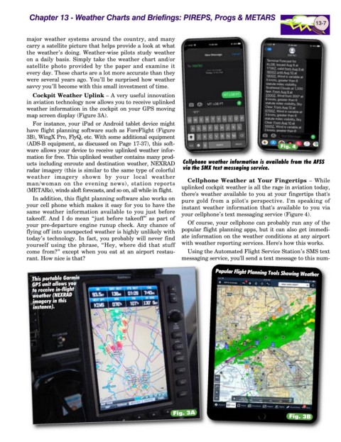
Popular Flight Planning Tools Showing Weather
This portable Garmin
GPS unit allows you
to receive in-flight
weather (NEXRAD
imagery in this
instance).
Fig. 3A
Fig. 3B