Page 39 - PDF_Flip_Book
P. 39

Chapter 12 - Understanding Weather
                                                                                                                12-37

                                                                                unstable, moist air and you have the pos-
                                                                                sibility for cumulonimbus (nimbus
                                                                                means rain) clouds, scattered thunder-
                                                                                storms and rain showers in advance of
                                                                                the front, as shown in Figure 62.
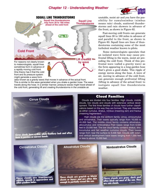
                                                                                    Fast-moving cold fronts can generate
                                                Fig. 63                         squall lines 30 to 180 miles in advance of
                                                                                and parallel to the front, as shown in
                                                                                Figure 63. Squall lines are lines of thun-
                                                                                derstorms containing some of the most
                                                                                turbulent weather known to pilots.
                                                                                    Some meteorologists speculate that
                                                                                an isolated wave form may cause pre-
                                                                                frontal lifting in the warm, moist air pre-
                                                                                ceding the cold front. Think of this pre-
                                                                                frontal wave (called a gravity wave) as
                                                                                the form appearing in a long garden hose
                                                                                that’s given a good shake. This ripple of
                                                                                energy moves along the hose. A wave of
                                                                                air, moving in advance of the cold front,
                                                                                can generate enough prefrontal lifting
                                                                                (lifting in advance of the actual front) to
                                                                                instigate squall line thunderstorm
                                                                                weather.


                                                                              Cloud Families
                         Cirrus Clouds                             Clouds are divided into four families: High clouds, middle
                                                                 clouds, low clouds and clouds with extensive vertical devel-
                                                                 opment. The first three families of clouds have further classifi-
                                                                 cations based on the way they are formed. They are classified
                                                                 as either cumulus, stratus, nimbus (meaning rain) and fractus
                                                                 (meaning fragmented).
                                                                      High clouds are the cirriform family: cirrus, cirrocumulus
                                                                 and cirrostratus. Their bases typically range from 16,500 to
                                                                 45,000 feet. The middle cloud family contains altostratus,
                                                                 altocumulus and nimbostratus.Their bases range from 6,500
                                                                 feet to 23,000 feet. The low cloud family contains stratus, stra-
                                                                 tocumulus and fair weather cumulus clouds. Their bases
             Cirrus clouds have a thin, white feathery look and often   range from near the surface to 6,500 feet. Clouds with exten-
             form in patches or narrow bands.                    sive vertical development have bases ranging from 1,000 feet
                                                                 or less to above 10,000 feet.


                 Cirrostratus Clouds                Altostratus Clouds                 Nimbostratus Clouds


              These clouds are transparent,      These clouds are grayish or bluish   These clouds are gray, dark and
              whitish, smooth in appearance and   sheets or layers and are often thin   often block out most of the sun. They
              often produce halos.               enough to partially reveal the sun.  are rain clouds.   © leiana - Fotolia
   34   35   36   37   38   39   40   41   42   43   44