
Page 35 - PDF_Flip_Book
P. 35
Chapter 12 - Understanding Weather
12-33
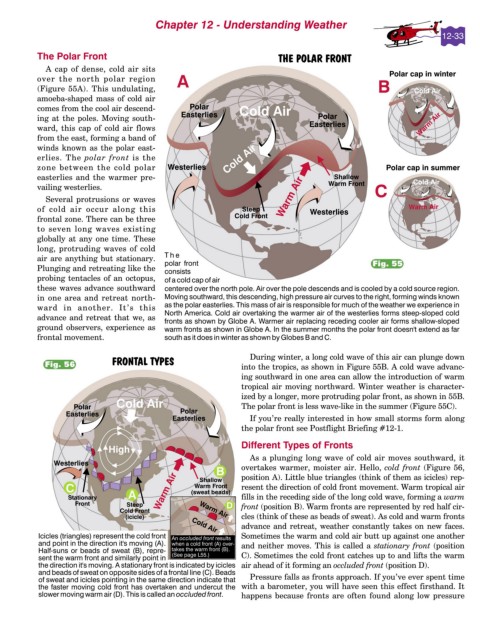
The Polar Front
A cap of dense, cold air sits
over the north polar region
(Figure 55A). This undulating,
amoeba-shaped mass of cold air
comes from the cool air descend-
ing at the poles. Moving south-
ward, this cap of cold air flows
from the east, forming a band of
winds known as the polar east-
erlies. The polar front is the
zone between the cold polar
easterlies and the warmer pre-
vailing westerlies.
Several protrusions or waves
of cold air occur along this
frontal zone. There can be three
to seven long waves existing
globally at any one time. These
long, protruding waves of cold
air are anything but stationary.
Fig. 55
Plunging and retreating like the
probing tentacles of an octopus,
these waves advance southward
in one area and retreat north-
ward in another. It’s this
advance and retreat that we, as
ground observers, experience as
frontal movement.
During winter, a long cold wave of this air can plunge down
Fig. 56 into the tropics, as shown in Figure 55B. A cold wave advanc-
ing southward in one area can allow the introduction of warm
tropical air moving northward. Winter weather is character-
ized by a longer, more protruding polar front, as shown in 55B.
The polar front is less wave-like in the summer (Figure 55C).
If you’re really interested in how small storms form along
the polar front see Postflight Briefing #12-1.
Different Types of Fronts
As a plunging long wave of cold air moves southward, it
overtakes warmer, moister air. Hello, cold front (Figure 56,
position A). Little blue triangles (think of them as icicles) rep-
resent the direction of cold front movement. Warm tropical air
fills in the receding side of the long cold wave, forming a warm
front (position B). Warm fronts are represented by red half cir-
cles (think of these as beads of sweat). As cold and warm fronts
advance and retreat, weather constantly takes on new faces.
Sometimes the warm and cold air butt up against one another
and neither moves. This is called a stationary front (position
C). Sometimes the cold front catches up to and lifts the warm
air ahead of it forming an occluded front (position D).
Pressure falls as fronts approach. If you’ve ever spent time
with a barometer, you will have seen this effect firsthand. It
happens because fronts are often found along low pressure