
Page 40 - PDF_Flip_Book
P. 40
Rod Machado’s Private/Commercial Pilot Handbook
12-38
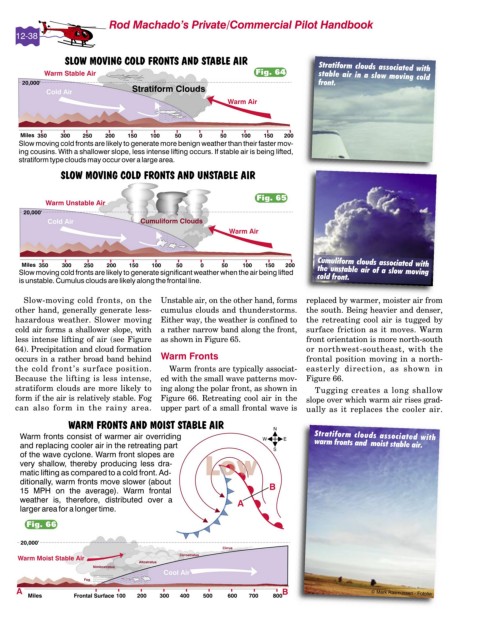
Stratiform clouds associated with
Fig. 64
stable air in a slow moving cold
front.
Fig. 65
Cumuliform clouds associated with
the unstable air of a slow moving
cold front.
Slow-moving cold fronts, on the Unstable air, on the other hand, forms replaced by warmer, moister air from
other hand, generally generate less- cumulus clouds and thunderstorms. the south. Being heavier and denser,
hazardous weather. Slower moving Either way, the weather is confined to the retreating cool air is tugged by
cold air forms a shallower slope, with a rather narrow band along the front, surface friction as it moves. Warm
less intense lifting of air (see Figure as shown in Figure 65. front orientation is more north-south
64). Precipitation and cloud formation or northwest-southeast, with the
occurs in a rather broad band behind Warm Fronts frontal position moving in a north-
the cold front’s surface position. Warm fronts are typically associat- easterly direction, as shown in
Because the lifting is less intense, ed with the small wave patterns mov- Figure 66.
stratiform clouds are more likely to ing along the polar front, as shown in Tugging creates a long shallow
form if the air is relatively stable. Fog Figure 66. Retreating cool air in the slope over which warm air rises grad-
can also form in the rainy area. upper part of a small frontal wave is ually as it replaces the cooler air.
Stratiform clouds associated with
warm fronts and moist stable air.
Fig. 66
© Mark Rasmussen - Fotolia