
Page 31 - PDF_Flip_Book
P. 31
Rod Machado’s Private/Commercial Pilot Handbook
10-10
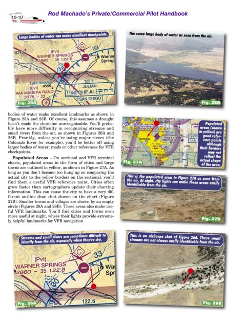
Large bodies of water can make excellent checkpoints. The same large body of water as seen from the air.
Fig. 25A Fig. 25B
bodies of water make excellent landmarks as shown in
Figure 25A and 25B. Of course, this assumes a drought
hasn’t made the shoreline unrecognizable. You’ll proba- Populated
bly have more difficulty in recognizing streams and areas (shown
small rivers from the air, as shown in Figures 26A and in yellow) are
26B. Frankly, unless you’re using major rivers (the good refer-
ence points
Colorado River for example), you’ll be better off using although
larger bodies of water, roads or other references for VFR their borders
checkpoints. may not
Populated Areas – On sectional and VFR terminal reflect the
charts, populated areas in the form of cities and large Fig. 27A actual shape
of the area.
towns are outlined in yellow, as shown in Figure 27A. As
long as you don’t become too hung up on comparing the
actual city to the yellow borders on the sectional, you’ll This is the populated area in Figure 27A as seen from
find them a useful VFR reference point. Cities often the air. At night, city lights can make these areas easily
identifiable from the air.
grow faster than cartographers update their charting
information. This can cause the city to have a very dif-
ferent outline than that shown on the chart (Figure
27B). Smaller towns and villages are shown by an empty
circle (Figures 28A and 28B). These areas also make use-
ful VFR landmarks. You’ll find cities and towns even
more useful at night, where their lights provide extreme-
Fig. 27B
ly helpful landmarks for VFR navigation.
Streams and small rivers are sometimes difficult to This is an airborne shot of Figure 26A. These small
identify from the air, especially when they’re dry. streams are not always easily identifiable from the air.
Fig. 26A Fig. 26B