Page 21 - IFR_Book_Sample-2020
P. 21
Ch-10 IFR Weather Charts-V8-NEW-NewUpdate_Basic Master Frame.qxd  12/19/2019  4:37 PM  Page 46


                  10-46             Rod Machado’s Instrument Pilot’s Handbook
                two you are most likely to have to deal
                with (even moderate turbulence is cer-
                tainly  no  fun).  A  light  aircraft  is  one
                that weighs less than 15,500 pounds. I
                think  that  means  you, unless  you’re     A
                bringing your flight bag with you again.
                You  definitely  want  to  avoid  severe
                (SEV) turbulence to say nothing about
                extreme  (E)  turbulence.  AIRMET
                Tango is displayed for turbulence only.
                It does not include AIRMET Tango for
                surface  winds  or  low-level wind  shear.
                Turbulence,    convective,   tropical
                cyclone,  and  international  thunder-
                storm  SIGMETs  are  also  overlaid.  You
                can  select  flight  levels  in  3,000  feet
                increments  when  looking  at  forecast
                turbulence.
                The Icing Forecast Button
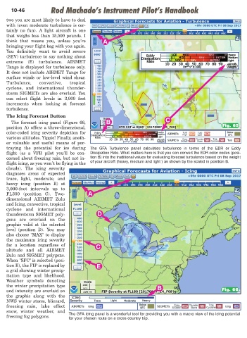
                  The  forecast  icing  panel  (Figure  66,  B                           C
                position  A)  offers  a  three-dimensional,                                                        Fig. 65
                color-coded  icing  severity  depiction  for
                various altitudes. Yippie! Finally, anoth-
                er  valuable  and  useful  means  of  por-
                traying  the  potential  for  ice  during  The  GFA  Turbulence  panel  calculates  turbulence  in  terms  of  the  EDR  or  Eddy
                flight  (as  a  VFR  pilot  you’ll  be  con-  Dissipation Rate. What matters here is that you can convert the EDR color codes (posi-
                cerned about freezing rain, but not in-  tion B) into the traditional values for evaluating forecast turbulence based on the weight
                                                      of your aircraft (heavy, medium and light ) as shown by the scaled in position B.
                flight icing, as you won’t be flying in the
                clouds).  The  icing  severity
                diagnoses  areas  of  expected
                trace,  light,  moderate,  and
                heavy  icing  (position  B)  at
                3,000-foot intervals  up  to
                FL300  (position  C).  Two-          A
                dimensional  AIRMET  Zulu
                and Icing, convective, tropical
                cyclone  and  international
                thunderstorm SIGMET poly-                D
                gons  are  overlaid  on  the
                graphic  valid  at  the  selected
                level  (position  D).  You  may
                also choose "MAX" to display
                the  maximum  icing  severity
                for  a  location  regardless  of         C
                altitude  and  all  AIRMET
                Zulu  and  SIGMET  polygons.
                When "SFC" is selected (posi-
                tion E), the FIP is replaced by          E
                a grid showing winter precip-
                itation  type  and  likelihood.
                Weather  symbols  denoting
                the winter precipitation type                                        B
                and intensity are overlaid on                                                                      Fig. 66
                the  graphic along  with  the
                NWS winter storm, blizzard,
                freezing  rain,  lake  effect
                snow,  winter  weather,  and
                                            The GFA icing panel is a wonderful tool for providing you with a macro view of the icing potential
                freezing fog polygons.
                                            for your chosen route on a cross country trip.

