
Page 48 - PDF_Flip_Book
P. 48
Chapter 17 - Pilot Potpourri: Neat Aeronautical Information
17-39
Sometimes manufacturers use the term TAS for their TCAD
devices. This can be a bit confusing but that’s the way aviation is
sometimes. TCAD devices are relatively inexpensive and serve a good
purpose in aviation. For instance, the Monroy TrafficWatch ATD-300
(Figure 32) unit sells for less than $650. These units are small, fit easi-
ly on the top of your panel and provide target distance and altitude
information. You shouldn’t, however, wear them on top of your head-
set. If you’re like me, you’ve probably already glued a small, spinning
propeller up there.
TIS
TIS or traffic information service provides traffic information in Fig. 32
terms of distance, bearing, direction of flight, and altitude. It doesn’t Picture Courtesy of Monroy Aerospace
provide resolution advisories. TIS requires that your airplane have a The ATD-300 Traffic-Watch is a passive receiver
Mode S transponder, like Garmin’s GTX330 (Figure 33), and some capable of detecting transponder replies from near-
means of presenting target information visually, such as a moving map by aircraft and displaying their range and altitude
display. TIS also requires that your aircraft be within range of a
ground station (Figure 34). A Mode S transponder does the same thing as a Mode A and C transponder, and a bit
more. It has the capability of uplinking the transponder data from other airplanes to your cockpit via the ground sta-
tion I just mentioned. This is how you get all that traffic information in your cockpit. The Mode S transponder also
transmits your airplane’s call sign and the transponder’s permanent unit code (not the four digit squawk code).
Here’s how TIS works. The ground based stations Garmin’s Mode S Transponder
(Figure 35) collect information on all transponder
equipped aircraft (operating in Modes A, C or S) and
uplink this information to your airplane’s Mode S
transponder (the GTX330 from Garmin that I just
mentioned). This information can then be displayed
on certain moving map displays, such as Garmin’s Fig. 33
400/500/1000 series GPS units. Not only can you see
altitude, direction and distance of the target aircraft, Garmin’s GTX330 is a Mode S transponder (retailing for about
but it’s possible on Garmin’s unit to see a target air- $5,000) that allows data uplinking/downlinking from ground based
transmitters (GBTs) to your airplane. The Mode S transponder is an
craft’s vector line (its direction of flight). Keep in
essential part of TIS (traffic information service).
mind that all this occurs without your airplane having
to actively interrogate or even passively identify another aircraft’s transponder. That’s because the TIS ground sta-
tion is doing all the work. Your Mode S transponder is providing the means of data uplink and your moving map dis-
play is electronically displaying the information received.
What you get with a Mode S transponder and a moving map display is the ability to do what the Avidyne/Ryan
TAS-600 or Goodyear’s SkyWatch system does, but at a price that might be affordable even if you’re not a publicly
held company. A Mode S transponder typically sells for less than $5,000 (if you purchase it from the back of a van in a
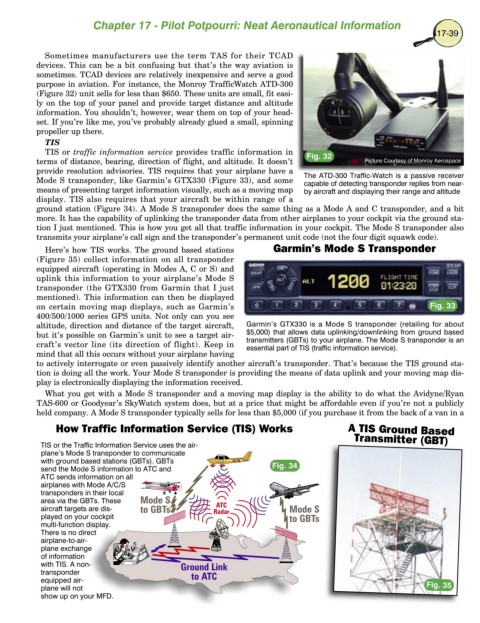
How Traffic Information Service (TIS) Works A TIS Ground Based
Transmitter (GBT)
TIS or the Traffic Information Service uses the air-
plane’s Mode S transponder to communicate
with ground based stations (GBTs). GBTs
send the Mode S information to ATC and Fig. 34
ATC sends information on all
airplanes with Mode A/C/S
transponders in their local
area via the GBTs. These
aircraft targets are dis-
played on your cockpit
multi-function display.
There is no direct
airplane-to-air-
plane exchange
of information
with TIS. A non-
transponder
equipped air- Fig. 35
plane will not
show up on your MFD.